
Objections & Suggestions receiving time period has been extended till 15.05.2024 as per 'Public Interest'
Master Plan for Coimbatore Local Planning Area
Planning Proposal

Twin City Development
The growth of Coimbatore appears to be following the same trend of development as that of Tiruppur. The portion of Coimbatore that is expected to experience the most expansion is the eastern half of the city, specifically along the Avinashi Road and the Trichy road. Because of the natural barrier that is the Western Ghats, there are limitations placed on the area of Coimbatore that is designated for development.
The undevelopable zone may be found in the western portion of the Coimbatore Local Planning Area (LPA). Tiruppur, on the other hand, is expanding toward the western section of the city, which is in the direction of Coimbatore. These two cities are projected to expand in a direction that is toward one another. As a result, Coimbatore and Tiruppur are considered to be Master plan for Coimbatore LPA 2041253 – twin cities due to the similar patterns of economic development that they exhibit.
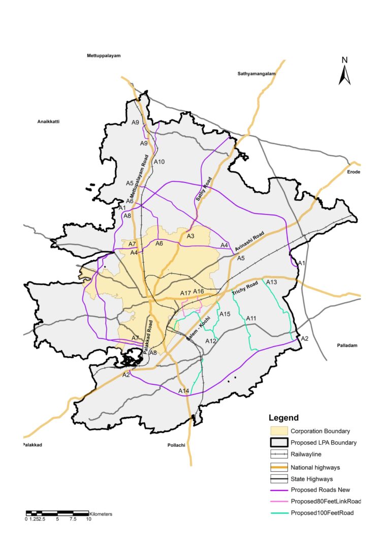
It has been determined that the rise of these two cities will serve as the economic centre that will be necessary for twin city development. The maps show the Existing Industrial growth centers Coimbatore LPA.
lntergrating Economic Growth Nodes with the Transportion Corridor
Integrating economic planning with the proposed transport network plan is a strategic approach to promote sustainable development , efficient resource allocation, and improved connectivity within a region or country. This integration involves coordinating economic goals, infrastructure development, and transportation systems to achieve better outcomes. The identified potential
economic growth centres are shown image.
The proposed 200 feet link roads on the eastern part are connecting the proposed economic growth nodes. The proposed 100 feet and 80 feet roads are connecting the 200 feet link roads. These roads can provide direct access to industrial areas, freight terminals, multimodal logistic park and other economic generating centres, thereby facilitating the movement of goods to and from manufacturing and distribution centres.
By aligning the two critical aspects of development – economic growth nodes and the transportation corridor, regions and countries can create synergies that promote economic prosperity, improved quality of life, and environmental sustainability.

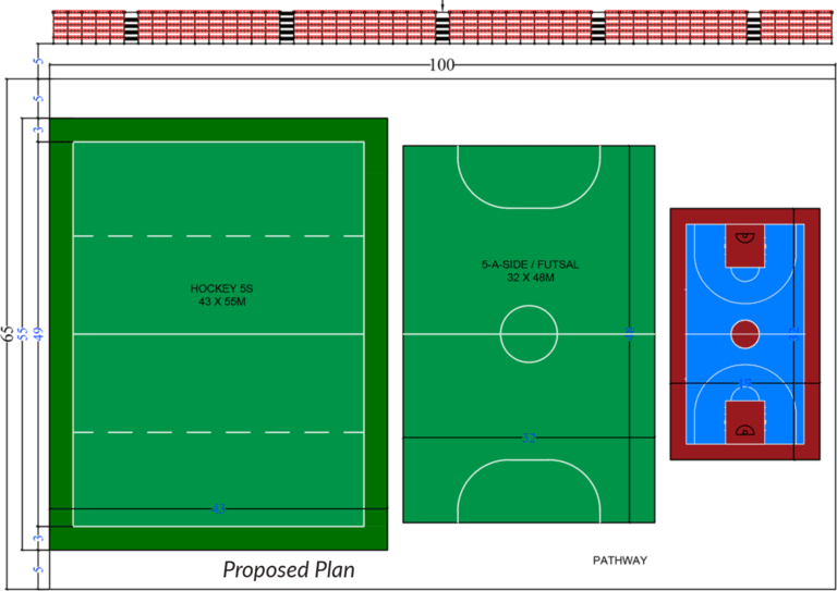
Multi use Sports complex - Proposed in RS Puram, Sastri Maidan along with the Hockey Ground.
MRTS - Metro Rail Project for Coimbatore

Mass Rapid Transit (MRT) systems move groups quicker over the same metropolitan corridor, lowering transportation expenses. Based on expanding demands and captive demand over the future, Coimbatore LPA may need MRTS and other transportation initiatives.
The Coimbatore Metro Rail project is a significant urban transportation initiative aimed at improving connectivity, reducing traffic congestion, and boosting economic and social development in the city of Coimbatore, Tamil Nadu, India.
|
|
Corridor
|
KM
|
Phase
|
|---|---|---|---|
|
C1
|
Vellalore to ukkadam to kaniyur via PSG
|
40.9
|
Phase I & II
|
|
C2
|
Collectorate to valiampalayam pirivu to Ganeshpuram
|
24.6
|
Phase I & II
|
|
C3
|
Karanampettai to pappampatti pirivu to periyanaickenpalayam
|
50.7
|
Phase I & II
|
|
C4
|
Townhall to Karunyanagar
|
22.7
|
Phase III
|
Road Network
The city’s transportation network is determined by its land use. The development of a transportation network strategy and land use must go hand in hand. Connectivity aids in the realisation of the planned land use. The developed land-use transportation strategy focuses on accessibility, connectivity, and mixed-use developments to reduce private vehicle trips and encourage transit-oriented development.
Long term, the transportation strategy should be based on the city’s anticipated urban growth. As a result, a transportation network strategy allows the city to adopt an urban form that best suits the geographical constraints of its location while also supporting the key social and economic activities of its residents. In accordance with regional development strategies, integrated land use and transportation development promotes balanced regional growth.
The scenario envisions the establishment of two ring roads: an inner ring road and a satellite ring road that interconnects the urban regions designated by the Local Planning Authority (LPA). These ring roads are set to be interconnected with the Western and Eastern Bypasses, along with a projected ring road and a link road connecting to Pollachi Road.
|
|
Proposed Road Network
|
Km
|
Phasing
|
|---|---|---|---|
|
A1
|
200 feet - Proposed (NH)Eastern Ring Road (Narasimanayakanpalayam to Karanampettai)
|
81.62
|
Phase 2
|
|
A2
|
200 feet - Proposed (NH) Sourthern Ring Road (Madukarai to Selakkarichel)
|
Phase 3
|
|
|
A4
|
100 feet - Proposed Road (Vilankurichi to Puliyampatti)
|
48.6
|
Phase 2
|
|
A5
|
100 feet - Proposed Road (Neelambur to Periyanayakanpalayam)
|
32.4
|
Phase 3
|
|
A6
|
80 feet - Proposed Road (Vellakinar to Mylampatti)
|
38.6
|
Phase 2
|
|
A7
|
80 feet - Proposed Link Road (Periyanayakkanpalayam to Chinnavedampatti)
|
15.8
|
Phase 3
|
|
|
Road Under Implementation
|
Km
|
Phasing
|
|---|---|---|---|
|
A3
|
150 feet - Proposed (NH) Western Ring Road (Madukkarai to Gudalur)
|
32.36
|
Phase 1
|
|
|
Proposed Widening of Roads 100 feet
|
Km
|
Phasing
|
|---|---|---|---|
|
B1
|
Irugur to Idayarpalayam
|
95.4
|
Phase 2 & 3
|
|
B2
|
Pattanam to Orattukuppai
|
||
|
B3
|
Sulur to Sellakaraichal
|
||
|
B4
|
Chettipalayam to Mailleripalayam
|
||
|
B5
|
Vellalur to Chettipalayam
|
|
|
Proposed Widening of Roads 80 feet
|
Km
|
Phasing
|
|---|---|---|---|
|
C1
|
Vellalur to Singanallur
|
16.4
|
Phase 2
|
|
C2
|
Vellalur to Ramanathapuram
|
Bus Terminals
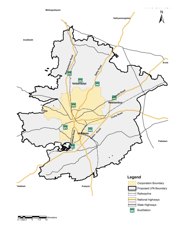
At the moment, all inter-city, inter-state, and intra-city buses originate and terminate at Gandhi Puram Bus Stand. Because this bus terminal is located in the city centre, all buses that terminate here cause significant congestion within the city. As a result, this bus terminal must be relocated. Furthermore, bus terminals are proposed to meet future demand:
- Bus Terminals:
Bus Stand at Vellalore, Neelambur, Vellamadai - Proposed intercity Bus Terminals
- Thudiyalur on Mettupalayam Road
- Between Neelambur and Chinniampalayam on Avinashi Road
- Perianaickenpalayam Town Bus Terminal at TNHB site nearby LGB
- Perur Bus Terminal at Perur Chettipalayam
- Vadavalli Bus Terminal at Vadavalli
- Madukkarai Bus Terminal at Madukkarai
- Kurumbapalayam on Sathy Road
- Relocation of Pollachi Bus Terminal at 10.97-acre available municipal land on Coimbatore – Pollachi Road (NH-209 ) near Sangampalayam.
- Bus Terminals:
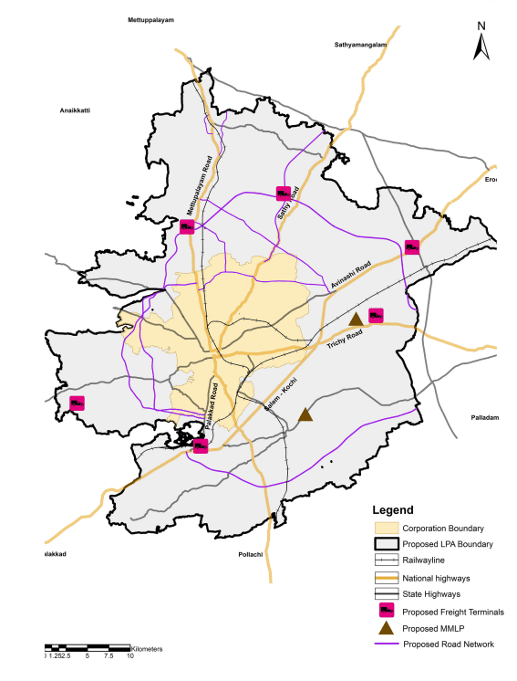
Freight Terminals
Freight transport management encompasses a variety of strategies for increasing the efficiency of commercial and freight transportation. Measures such as restricted delivery times in the central business district and important freight corridors To address the large influx of goods and regional traffic, it is proposed to build truck terminal facilities along the proposed ring road.
- Karumathampatti on Avinashi Road
- Pooluvampatti on Perur Road
- Madukkarai on Palakkad Road
- Near Sulur on Trichy Road
- Malumichampatty on Pollachi Road
- Narasimhanaickenpalayam on Mettupalayam Road
- Kovilpalayam on Sathy Road
Participate in Building Your Future
We are seeking objections and suggestions by feedback from the public on the Master Plan and the Proposed future for Coimbatore LPA.
HI-RES PRINTED MAPS AND REPORT ARE AVAILABLE FOR VIEWING AT

Objections and Suggestions

or
Scan or Click the button to fill the Objection and Suggestion form
Downloads